Table 15 Waypoints of the Recommended Route from Bai Yu to Nanri Shuidao via Mu Yu
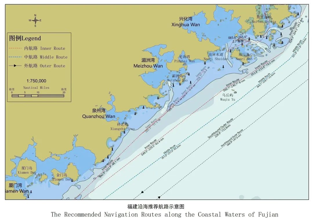
1.16 Nanri Shuidao- Xiangzhi Jiao (Southbound)
The southbound route from Nanri Shuidao to Xiangzhi Jiao consists of two sections: from Nanri Shuidao to Pinghai Wan and from Pinghai Wan to Xiangzhi Jiao.
①Nanri Shuidao-Pinghai Wan
Due the effects of Pinghai Wan offshore wind farm, the route from Nanri Shuidao to Pinghai Wan is currently being optimized and adjusted. Vessels are advised to navigate with cautions by checking the sailing directions (to be released) and other nautical publications for water depth, obstacles, aids to navigation, as well as the wind, waves, tides, and their own conditions. Southbound vessels are recommended to navigate on the north side of the water area. These southbound vessels should keep appropriate communication with other northbound vessels and avoid encounter situations in the Jian Yu buoy light waters. All vessels should remain radio watchkeeping via VHF to receive necessary information from local MSA and O&M department of offshore wind farms. Vessels will enter the following section of the route when sailing to the A50 waypoint point (25°07'47.6"N, 119°16'35.0"E).
②Pinghai Wan- Xiangzhi Jiao
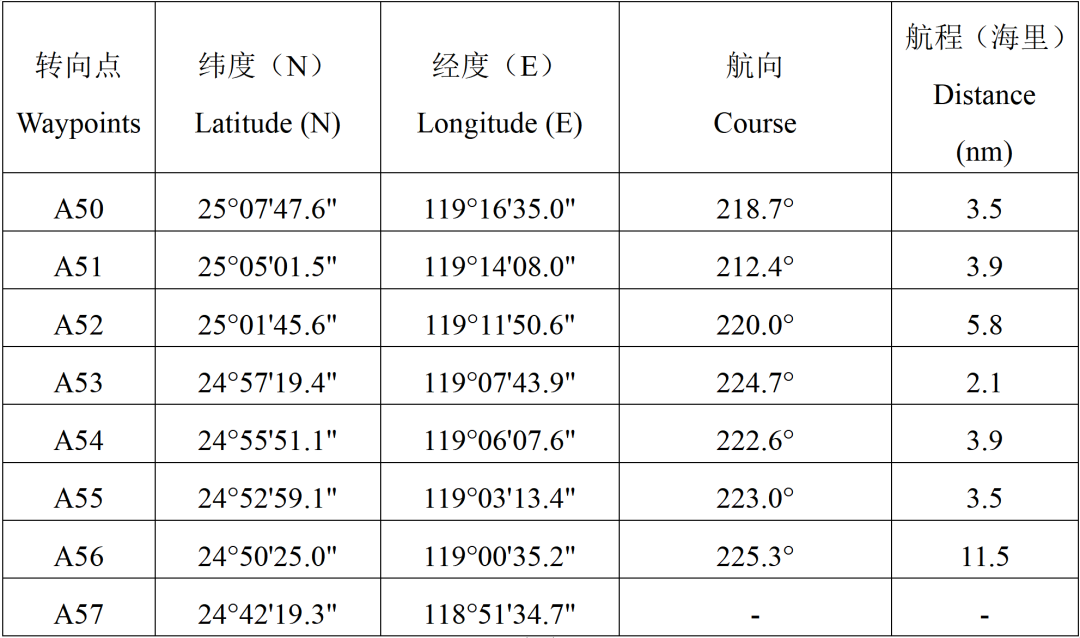
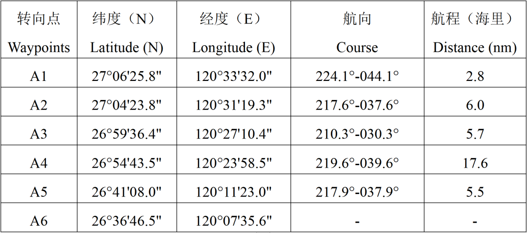
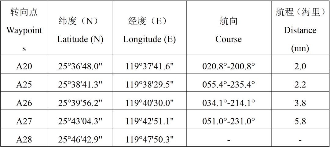
Table 16 Waypoints of the Recommended Route between Pinghai Wan and Xiangzhi Jiao
1.17 Xiangzhi Jiao-Nanri Shuidao (Northbound)
The northbound route from Xiangzhi Jiao to Nanri Shuidao consists of two sections: from Xiangzhi Jiao to Pinghai Wan and from Pinghai Wan to Nanri Shuidao.
①Xiangzhi Jiao-Pinghai Wan
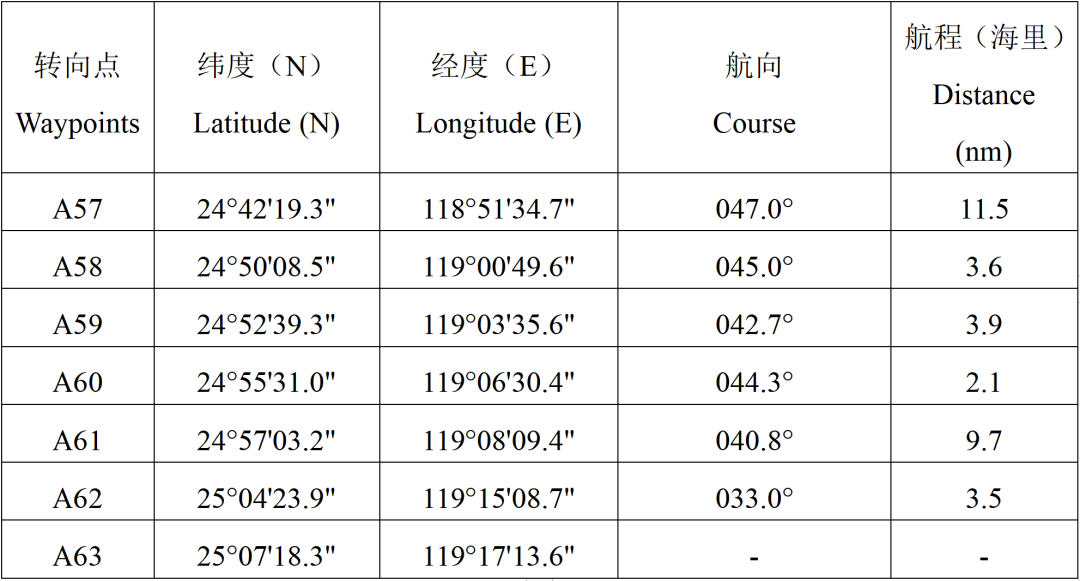
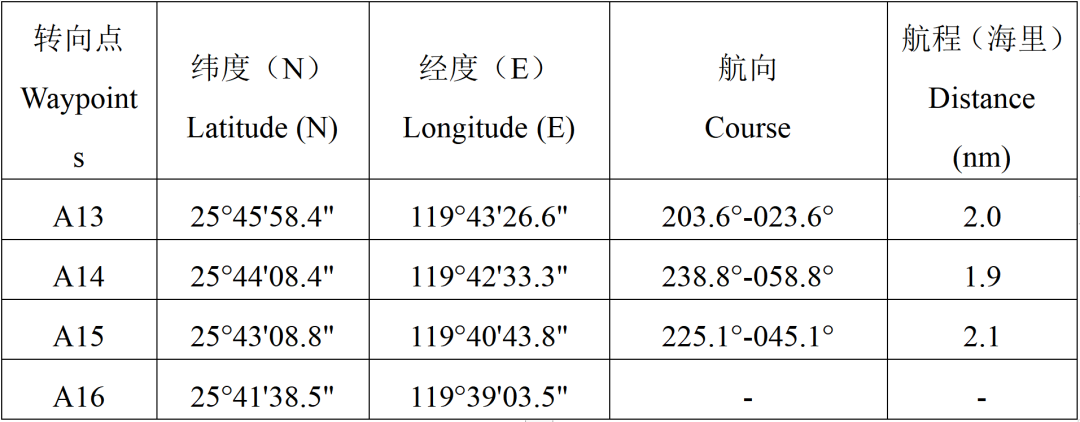
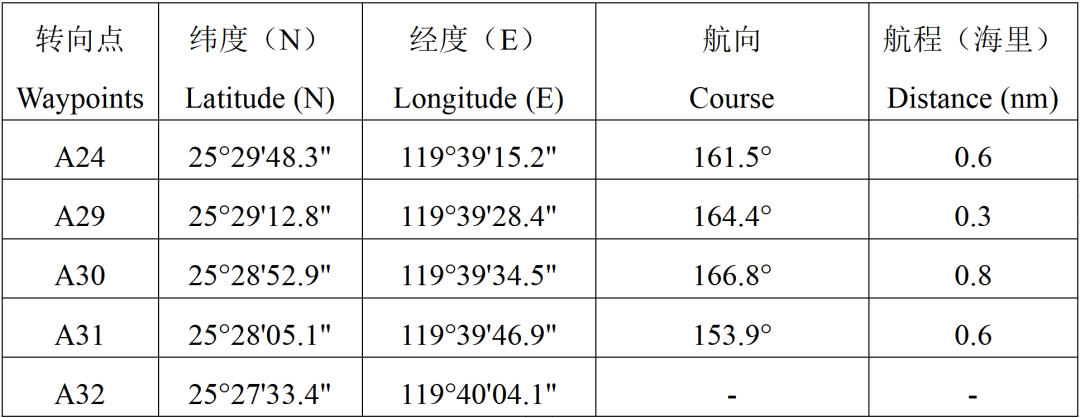
Table 17 Waypoints of the Recommended Route between Xiangzhi Jiao and Pinghai Wan
②Pinghai Wan-Nanri Shuidao
Due the effects of Pinghai Wan offshore wind farm, the route from Nanri Shuidao to Pinghai Wan is currently being optimized and adjusted. Vessels are advised to navigate with cautions by checking the sailing directions (to be released) and other nautical publications for water depth, obstacles, aids to navigation, as well as the wind, waves, tides, and their own conditions. Northbound vessels are recommended to keep clear of aids to navigation and turbines in the offshore wind farm waters, remain communication with southbound vessels to avoid collisions, especially encountering other vessels in the Jian Yu light buoy waters. All vessels should remain radio watchkeeping via VHF to receive necessary information from local MSA and O&M department of offshore wind farms..
1.18 Xiangzhi Jiao-Dongding Dao

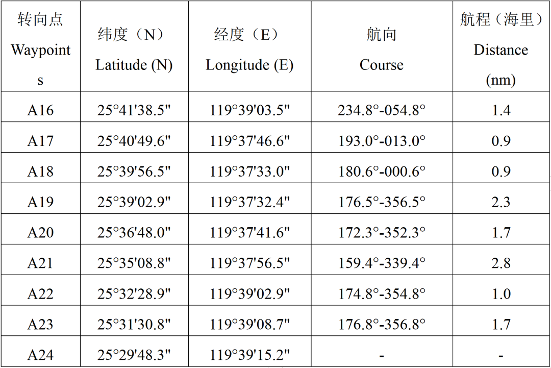
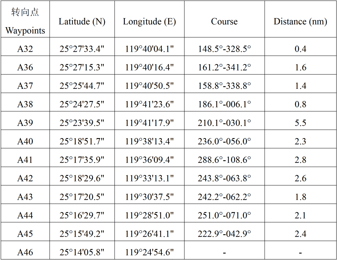
Table 18 Waypoints of the Recommended Route between Xiangzhi Jiao and Dongding Dao
1.19 Minjiang Kou-Dongxiang Jiao (Southbound)
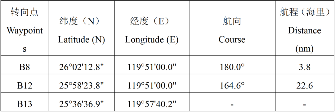
Table 19 Waypoints of the Recommended Route between Minjiang Kou and Dongxiang Jiao (Southbound)
1.20 Dongxiang Jiao-Minjiang Kou (Northbound)

Table 20 Waypoints of the Recommended Route between Dongxiang Jiao and Minjiang Kou (Northbound)
1.21 Dongxiang Jiao-Dongshan Dao
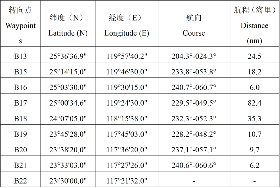
Table 21 Waypoints of the Recommended Route between Dongxiang Jiao and Dongshan Dao
Recommended Middle Routes
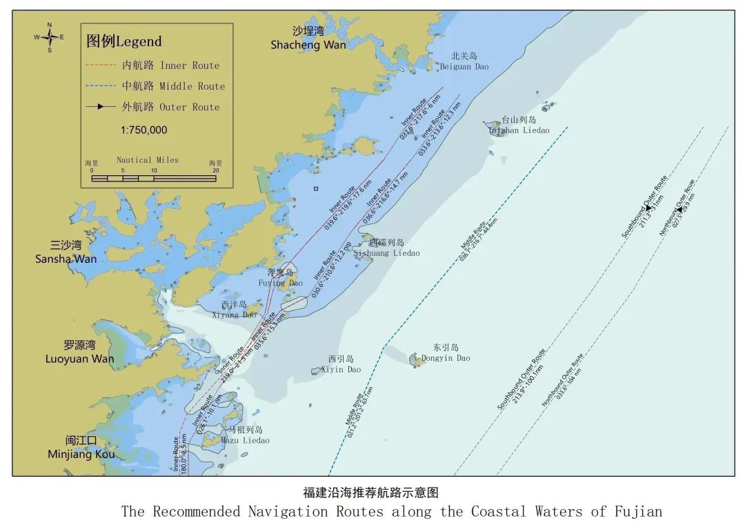
The middle route connects northern boundary (the coastal waters between Fujian and Zhejiang, east of Taishan Dao) and southern boundary (the coastal waters between Fujian and Guangdong). This route is a common route for medium-sized vessels that passing or calling major ports along the coast of Fujian. The middle route is straight and less waypoints in open sea areas, thereby with no limitations of depth and height of navigational clearance. The navigation aids system is well developed for necessary positioning for the medium and large vessels. The width of this route is not set. It is recommended that southbound vessels navigate along the west side and northbound vessels navigate in the east side to reduce encounters. The waypoints of the recommended middle route are shown in the table below.
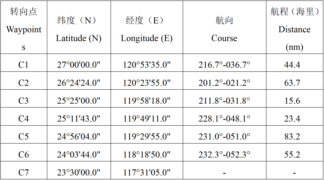
Table 22 Waypoints of the Recommended Middle Route
Recommended Outer Routes
The outer route starts from the boundary between the coastal areas of Fujian and Zhejiang (north) and ends at the boundary between the coastal areas of Fujian and Guangdong (south). The middle route is straight and less waypoints in open sea areas, with no limitations of depth, width and air clearance. The route is far from the shore, hence the mainly effects are wind and waves, with few landmarks available for positioning. This route is suitable for large vessels navigating under all weather conditions, and suit for medium-sized vessels navigating under good weather and sea conditions. This route consists of the northbound outer route and the southbound outer route, which are relatively separated. The corresponding routes should be considered for all vessels based on their directions. The recommended turning points are shown in the table below.
(1)Southbound Outer Route

Table 23 Waypoints of the Recommended Outer Route (Southbound)
(2)Northbound Outer Route
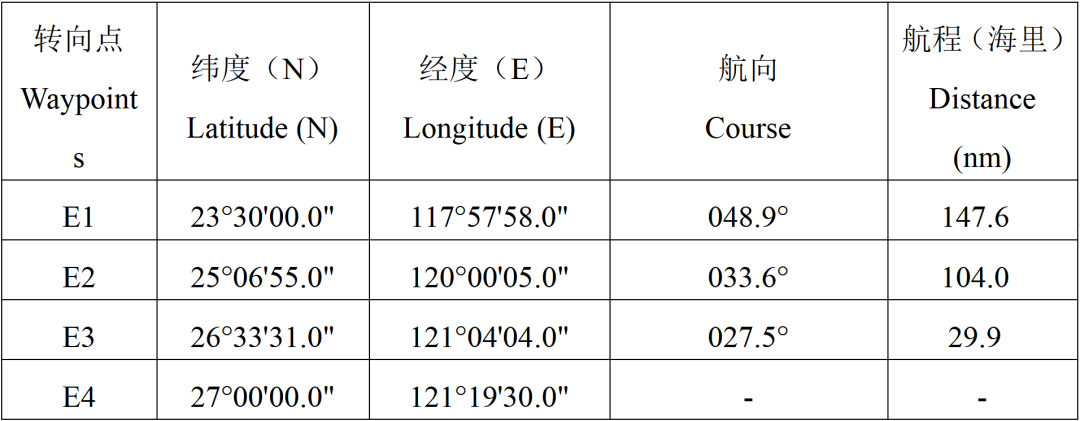
Table 24 Waypoints of the Recommended Outer Route (Northbound)
Source:
Fujian MSA
The opinions expressed herein are the author's and not necessarily those of The Xinde Marine News.
Please Contact Us at:
media@xindemarine.com








 China’s First Bulk Bunkering of Domestic Green Me
  Rotterdam and Singapore Strengthen Collaboration on
  MPA and CMA CGM Sign MoU to Enhance Sustainable Shi
  China's Ports Surge Ahead: Major Container Terminal
  Port of Hamburg: Growth in container throughput and
  EPS and SPDB Financial Leasing sign financing agree