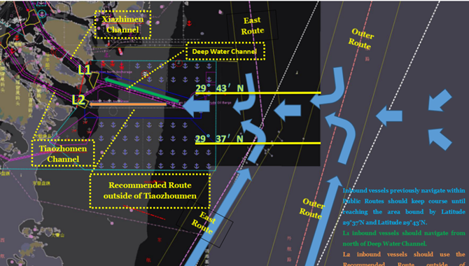
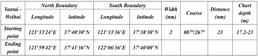
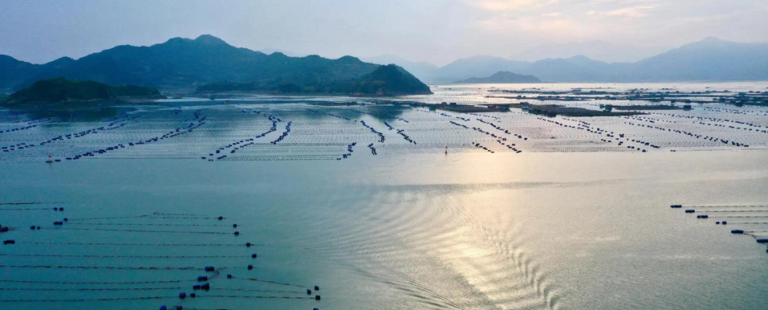
1. The Fishery Farms off Laizhou
The fishery farms off Laizhou Port expanded disorderly in the past years, from the below illustration, you will note that some of the fishery farms are near or even within the recommended channel.
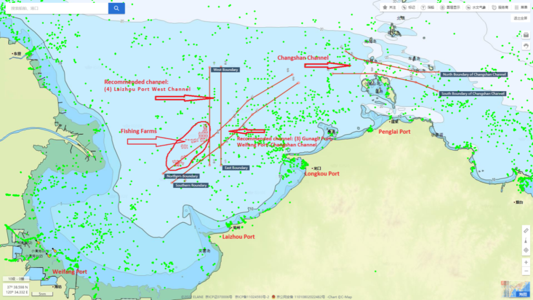
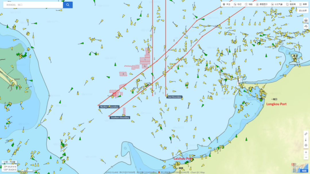
The overview of the two recommended channels and the fishery farms off Laizhou
Zoom-in view of the fishery farms and the two recommended channels
From the above illustrations, you will note that west-bound ships sailing out of Changshan Channel to Weifang Port, or sailing from Penglai / Longkou / other northern Ports to Weifang Port, are exposed to high risks of entering the fishery farms off Laizhou.
Loss Prevention Suggestions:
A. Ships shall sail in the day time when she is in the above sea area, and the duty officer shall a keep sharp lookout during the navigation.
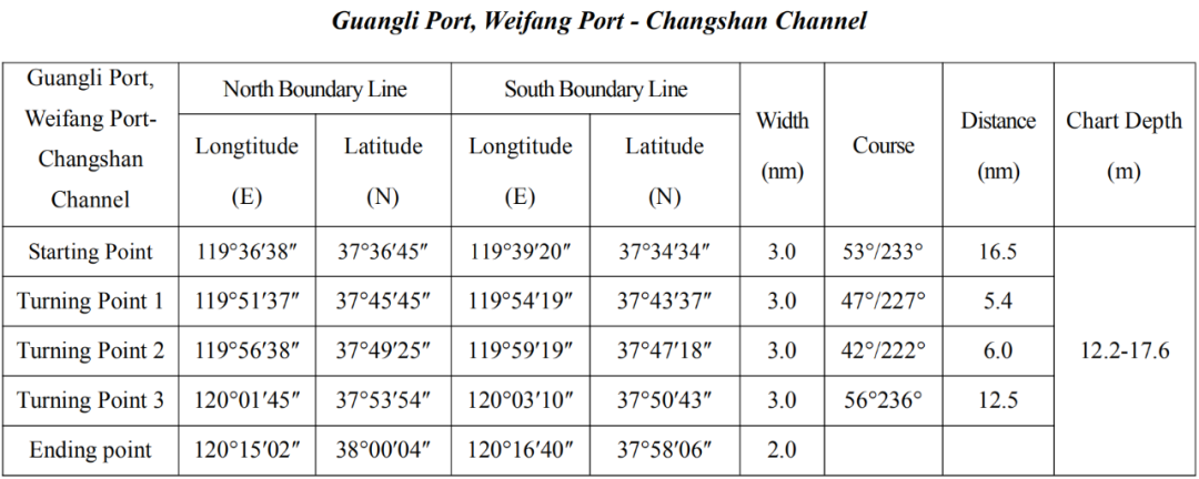
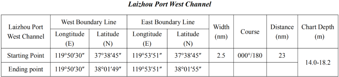
B. Ships should proceed along the course of the two recommended channels as below:
A. The master should carefully peruse the e-mails sent by the local agent regarding the positions of fishery farms and plot them on the ECDIS or paper charts in advance for purpose of clear navigation guidance. If no information is provided by the local agent, ask for it.
B. The master should contact the MSA if the vessel is entangled by the fishing ropes or nets.
Please Note:
1. The fishery farms in the above chart are just small parts of the fishery farms in that area which are obtained during our case handling, and most of them are not plotted on the chart due to limited information available.
2. It is noted that any claims for damage to fishery farms within the recommended channels are usually not upheld by the local authorities.
2. The Fishery Farms off Yantai
In recent months, there have been substantial claims for damages caused by ships entering the fishery farms which are located close to the south boundary of the recommended channel from Yantai to Weihai.
In order to avoid occurrence of further accident, Yantai MSA has issued series of Navigation Notices regarding the information of fishery farms within their jurisdiction on their website , and the latest one is (Lu Hang Tong [2022] 0413).
QUOTE
Fishery farm range in the sea area south of Yantai - Weihai public Channel
Fishery farms are found within the sea area connected by the following four coordinates:
The distance between the north boundary of the fishery farm area and the south boundary of the channel is 200m, and the ships passing by should strengthen lookout and navigate cautiously to avoid entering those farms.
(2). This Notice is only used as navigation safety information for passing ships.
UNQUOTE
Meanwhile, please note the recommended channel (Yantai Port to Weihai Port) mentioned in the “Notice on the Announcement of Some Sea Routes along the Shandong Coast” (Lu Hang Tong [2021] 0376) has been adjusted by the MSA Navigation Notice (Lu Hang Tong [2022] 0059) on Feb. 10th, 2022 as below:
QUOTE
In order to ensure the safety of ship navigation and maintain the navigation order, the range of “Yantai Port to Weihai Port” in “Notice on the Announcement of Some Sea Routes along the Shandong Coast (Lu Hang Tong [2021] 0376)”
has been adjusted. The adjusted route parameters are as follows:
The rest remains unchanged.
UNQUOTE
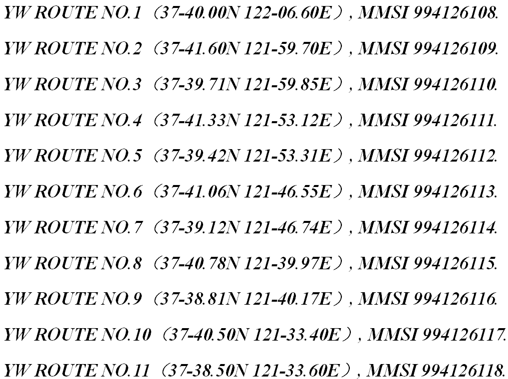
In addition, in order to give adequate warning to ships to avoid passing through the fishery farms, the MSA established 11 virtual AIS Marks on the adjusted channel from Yantai to Weihai. According to the MSA Navigation Warning (Lu Hang Jing 0367) published on Aug. 08, 2022:
QUOTE
YELLOW SEA, ELEVEN VIRTUAL AIS MARKS ESTABLISHED ON THE ROUTE FROM YANTAI TO WEIHAI.
CAUTION ADVISED.
UNQUOTE
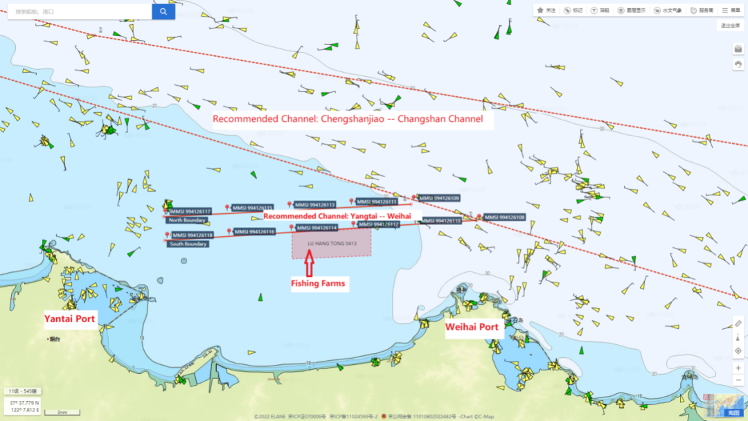
Lu Hang Tong〔2022〕0413 and the adjusted channel (with 11 virtual AIS marks)
Loss Prevention Suggestions:
A. Ships should proceed along the course of the recommended channel (adjusted) when they sail between Yantai port and Weihai port.
B. The duty officer should keep a sharp lookout during the navigation in that area. The floating balls are visible when the weather and sea condition being favorable during the day time, and the AIS reflector signals from the boundaries of the fishery farms are discoverable on ship’s AIS or ECDIS.
C. The master should carefully peruse the e-mails sent by the local agent regarding the position of fishery farms and plot on the ECDIS or paper charts in advance. If no information is provided by the local agent, ask for it.
D. The master should contact the MSA if the vessel is entangled by the fishing ropes or nets.
Please Note:
There are some unidentified fishery farms that are not included in the above navigation notice. The duty officer should keep a sharp lookout during the navigation in that sea area.
3. The Fishery Farms off Longkou
In order to avoid fishery farm damage cases off Longkou Port, the MSA issued a Navigation Notice (Lu Hang Tong [2022] 0230) on the information of fishery farms in the sea area enclosed by the following four coordinates and the coastline:
A:37°41′30″N, 120°12′20″E;
B:37°50′00″N, 120°12′20″E;
C:37°50′00″N, 120°23′42″E;
D:37°43′50″N, 120°25′16″E。
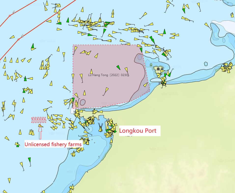
Lu Hang Tong [2022] 0230
In the Navigation Notice, the MSA points out the following precautions:
1) The Fishery farms boundary changes with seasons, and ships passing by should strengthen lookout and navigate cautiously to avoid passing through those farms.
2) This Notice is only used as navigation safety information for passing ships.
Please Note:
There are some unidentified fishery farms that are not included in the above navigation notice (such as the following two unlicensed fishery farm A and B). The duty officer should keep sharp lookout during the navigation in that sea area.
Fishery Farm A
 Fishery Farm B

4. The Fishery Farms off Penglai
In order to avoid fishery farm damage cases off Penglai Port, the MSA issued a Navigation Notice on the information of fishery farms in the sea area enclosed by the following coordinates:
A:37°57′54″N, 120°48′48″E;
B:37°58′00″N, 120°51′48″E;
C:37°57′42″N, 120°52′42″E;
D:37°55′24″N, 120°52′42″E;
E:37°52′48″N, 120°49′30″E;
F:37°52′56″N, 120°46′42″E;
G:37°55′00″N, 120°46′22″E;
H:37°55′53″N, 120°46′22″E;
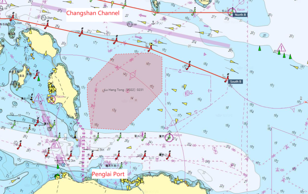
Lu Hang Tong [2022] 0231
In the Navigation Notice, the MSA points out the following precautions:
1) The Fishery farms boundary changes with seasons, and the ships passing by should strengthen lookout and navigate cautiously to avoid passing through those farms.
2) This Notice is only used as navigation safety information for passing ships.
Source: Huatai
The opinions expressed herein are the author's and not necessarily those of The Xinde Marine News.
Please Contact Us at:
media@xindemarine.com


.gif)


 China’s First Bulk Bunkering of Domestic Green Me
  Rotterdam and Singapore Strengthen Collaboration on
  MPA and CMA CGM Sign MoU to Enhance Sustainable Shi
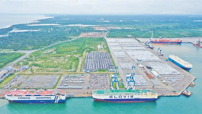
  China's Ports Surge Ahead: Major Container Terminal
  Port of Hamburg: Growth in container throughput and
  EPS and SPDB Financial Leasing sign financing agree