ECDIS使用识图问题:
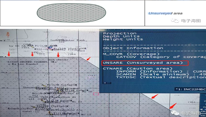
1.Unsurveyed area(以英文解释为准)
ENC producers will sometimes have to include areas on their charts where there is no survey data, on where only basic survey data is available in complicated waters with many hazards to navigation, and which is therefore not adequate to support safe navigation.
An ECDIS will display these unsurveyed areas using a filled grey symbol with a dashed line pattern, as illustrated below. The ENC producer is therefore high lighting that it is not safe to enter these waters given the level of information that is available about the area.
ENC生产商有时不得不在他们的海图图幅范围内包含没有调查数据的区域,在这些复杂危险的航行区域只有一些基础的测量数据,不足以满足安全航行的需要。
ECDIS将使用带虚线填充灰色符号显示这些未测量的区域,如下图所示。因此,ENC生产者强调,鉴于有关该地区的现有测量数据,进入这些水域是不安全的。

2.Dredged area:
Dredged areas are shown by a grey dotted area fill patternas shown below:
疏浚水深:疏浚区以灰点填充模式显示,如下图所示:
Note: Depending on how the producer nation has captured the dredged area feature, the dredged / maintained depth value may not always display automatically. Where the value is not visible, the ECDIS pick report function can be used to view the value, where it will be described as 'DepthRange Value I' (DRVALI)
注意:不同的ENC生产国显示疏浚区域水深值方式有所不同,疏浚/维护水深值可能并不总是直接显示。当该值不可见时,使用ECDIS的pick report功能查看该值,该值将被描述为“Depth Range value 1”(DRVAL1)


3.Automatic update
自动更新是ENC的每周更新数据被ECDIS软件更新到SENC数据库的一种更新。完成ECDIS自动更新后,使用者可以选择查看更新的位置。在IHO Presentation Library 4.0中使用的符号如下所示。正常显示时一般把自动更新处于关闭的位置。


下图为FURUNO FMD3200型号的ECDIS的自动更新显示控制。

4.No overlay又是什么?
AlO only provides this overlay information to the ENC data for those areas where there is an equivalent scale Admiralty paper chart. Where one does not exist, this is indicated by the 'No Overlay'feature which is displayed as a grey polygon with a grey hatched fill. When navigating in these areas, mariners should ensure that all appropriate sources of information have been consulted, for example any national or local T&P NMs that may be available.
AlO提供的叠加信息只提供于具有同等比例尺英版纸质海图的区域(因为AIO中的TP信息完全来源于纸质海图的TP)。在不存在相应比例尺纸质海图的地方(即这个区域有大比例尺ENC海图,但是没有相应大比例尺纸质海图),就会用“NO OVERLAY”特征表示,该特征为一个灰色多边形,填充为灰色阴影。在这些区域航行时,船员应确保所有适当的信息来源都得到了考虑,例如任何国家或当地可能提供的临告预告。

NAVTOR使用常见问题:
1.NAVTOR海图更新问题。
经常会有人问到用NAVTOR更新数据,如果中途漏掉一期或者多期没有更新,这些漏掉的更新数据能否得到更新?
答:能得到更新的,最后一次更新会把所有的数据更新到最新。
每次更新的时候后台能自动识别NAVSTICK或者NAVBOX里面的数据是哪一期的,也能识别船上现存有效的ENC海图,识别后会针对船上目前数据和有效的ENC海图来推送船上所需要的更新。
2.NAVTOR网络不稳定或无网络时更新方法。Offline
有时候网络不稳定更新很慢,或者没网络的情况如何来更新数据?
网络不稳定时,会长时间显示如下界面。可以使用离线方式更新。即通过E-mail的方式来更新,这样可以节省更新时间。离线更新方式参见NAVSYNC说明。

当无法直接连接网络的时候会显示如下界面,此时可用离线方式更新数据。

免责声明:本文仅代表作者个人观点,与信德海事网无关。其原创性以及文中陈述文字内容和图片未经本站证实,对本文以及其中全部或者部分内容文字、图片的真实性、完整性、及时性本站不作任何保证或承诺,请读者仅作参考,并请自行核实相关内容。
投稿或联系信德海事:
media@xindemarine.com

07-02 来源:厦远船员管理
10-13 来源: 连云港海事
10-04 来源:信德海事网 郭建平
08-02 来源:信德海事网
06-07 来源: 海丰保险
01-19 来源:信德海事网
08-25 来源:雪球
07-24 来源:信德海事网
08-10 来源:信德海事网
10-28 来源:信德海事网