While a continued downward trend in Somali piracy has prompted leading shipping organisations to reduce the geographic boundaries of the 'High Risk Area' for piracy in the Indian Ocean, vessels transiting these waters must remain vigilant and be aware of the evolving maritime security landscape.
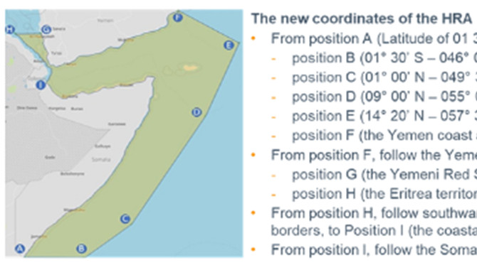
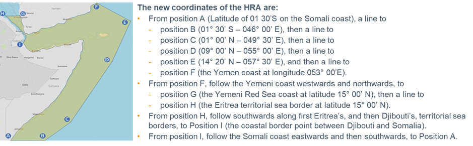
On 17 August 2021, BIMCO, ICS, INTERCARGO, INTERTANKO, and OCIMF, representing the global shipping and oil industries, announced an agreement to reduce the boundaries of the piracy High Risk Area (HRA) in the Indian Ocean as incidents in the region continues to decrease. The changes will come into effect on 1 September 2021 and will, in broad terms, reduce the HRA boundaries to the Yemeni and Somali Territorial Seas and Exclusive Economic Zones in its eastern and southern reaches.
A copy of the joint press release, which also contains the illustrative map and the exact coordinates of the revised HRA shown below, can be downloaded from the “Red Sea, Gulf Of Aden, Somali Basin, Arabian Sea” section of the
Maritime Global Security website.
The geography of the Indian Ocean region is, however, diverse and ranges from narrow choke points such as the Bab el-Mandeb Strait and the Strait of Hormuz to the wide-open ocean of the Somali basin. Each area presents different challenges and threats will vary. Hence, whilst the trimming of the HRA boundaries may signal a step in the right direction where Somali piracy is concerned, all vessels transiting the Indian Ocean waters are encouraged to continue to remain vigilant and be aware of the evolving maritime security landscape. Remember that preparation and planning is key and that the consequences of not adopting effective security measures can be severe.
Somali piracy
The HRA was created at the height of the Somali piracy threat in 2010 to show shipowners, operators, and seafarers where pirates operated and where extra vigilance was required to avoid attacks. Subsequent updates to the HRA have reflected the changing nature of the threats in the region, including the successful suppression of Somali pirate action.
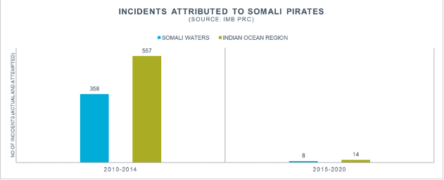
According to the IMB PRC, the total number of attacks in the Indian Ocean region that could be attributed to Somali pirates peaked in 2011, when 237 incidents were recorded, and soared to 557 during the five-year period between 2010 and 2014. This number fell dramatically to just fourteen in the six-year period between 2015 and 2020, a drop that is widely regarded as a result of joint efforts to reduce crimes at sea. At the time of writing, Somali pirate groups have reportedly not succeeded in attacking a merchant vessel since 2017.
Notes of caution
• Despite the reduction in Somali piracy, the IMB PRC warns that Somali pirate groups continue to possess the capacity to carry out attacks in the Somali basin and wider Indian Ocean. They also tend to be well armed with automatic weapons, RPGs and have been known to use skiffs launched from mother vessels, which may be hijacked fishing vessels or dhows. All merchant ships are therefore advised to adhere to the recommendations in the latest industry Best Management Practices (BMP) while transiting these waters.
• The HRA forms only a part of the area denoted as the ‘Voluntary Reporting Area’ (VRA) as defined in the BMP. Ships are encouraged to register with the Maritime Security Centre Horn of Africa (MSCHOA) and report to the United Kingdom Maritime Trade Operations (UKMTO) prior to entering the region.
• Threats are dynamic and a pre-transit risk assessments must consider the latest information on current threats in both the VRA and HRA. Information should be sought from the organisations listed in Annex A of the BMP and ships should be prepared to deviate from their planned route at short notice to avoid threats highlighted by navigation warnings or by military forces.
• The conflict in Yemen has introduced additional maritime security threats, other than piracy, to the Southern Red Sea and Bab al-Mandeb. Ships transiting this area are recommended to use the established Maritime Security Transit Corridor (MSTC), a military established corridor upon which naval forces focus their presence and surveillance efforts.
It is also worth noting that the recently amended HRA boundaries relate to the implementation of BMP measures only. The Indian Ocean region is also a Joint War Committee (JWC) listed area and a high risk area for IBF/ITF crew contracts, however, the coordinates/boundaries of these areas do not coincide with the piracy HRA.
Source: Gard
The opinions expressed herein are the author's and not necessarily those of The Xinde Marine News.
Please Contact Us at:
media@xindemarine.com


.gif)


 Baltic Exchange launches new Fuel Equivalence Conve
  21 Consecutive Years of QUALSHIP 21 Recognition for
  MPA and Wärtsilä Renew Partnership to Drive Marit
  MPA and Dalian Maritime University Renew Partnershi
  PSA INTERNATIONAL, DNV AND PACIFIC INTERNATIONAL LI
  INTERCARGO Reaffirms Call for Simplicity as IMO Cli