This article contains crucial information regarding anchoring in Ningbo-Zhoushan VTS zone NO.1 and its nearby areas, providing clarification and guidance for international seafarers.
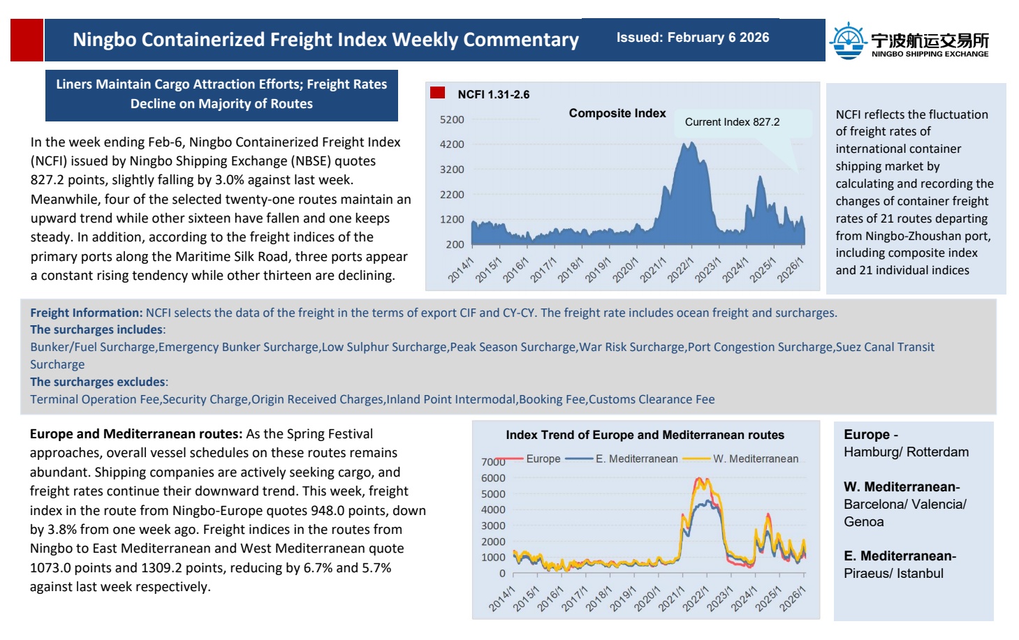
01 VTS ZONE NO.1
The water area formed by the East of the connection line between Xiaolaohu light beacon and SE of the Taohua Dao (29°47′.50N/122°16′.30E), and the line connecting these points as follow:
(a) 29°46′.51N/122°19′.32E;
(b) 29°46′.51N/122°34′.90E;
(c) 29°34′.50N/122°34′.90E;
(d) 29°34′.50N/122°18′.47E;
(e) 29°37′.54N/122°13′.97E;
(f) Liuheng Dao Wai Jiao light beacon;
(g) Taohua Dao Dongtiao Zui
(29°44′.68N/122°18′.22E).
The water area formed by the following points is the traffic organization area:
(h) 29°45′.13N/122°20′.22E;
(i) 29°45′.33N/122°20′.30E;
(j) 29°42′.00N/122°33′.007E;
(k) 29°40′.23N/122°33′.01E;
(l) 29°40′.23N/122°18′.43E;
(m) 29°41′.23N/122°18′.43E.
Anchoring in the traffic organization area is prohibited except for special circumstances.


Figure 1. VTS Zone No.1
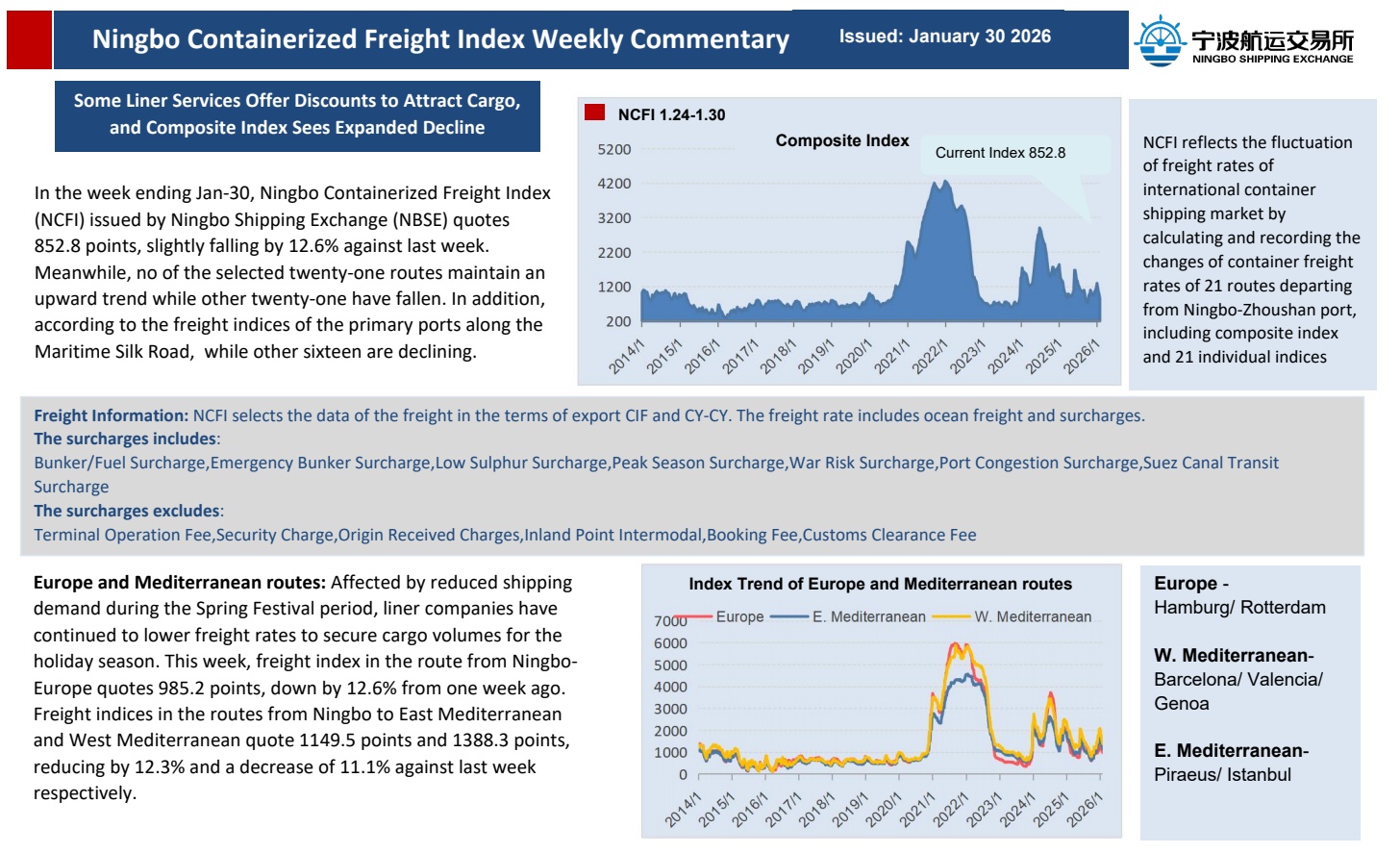
02 ANCHORING SECTORS
Apart from Xiazhimen northern anchorage and Tiaozhoumen anchorage, there are four anchoring sectors in VTS zone NO.1 area, sector A, sector B, sector C and sector D, as shown in Figure 2.
Vessels are to use Xiazhimen channel(Reporting Line 1) should anchor in sector A, B and D, and vessels are to use Tiaozhoumen channel(Reporting Line 2) should anchor in sector C and D.
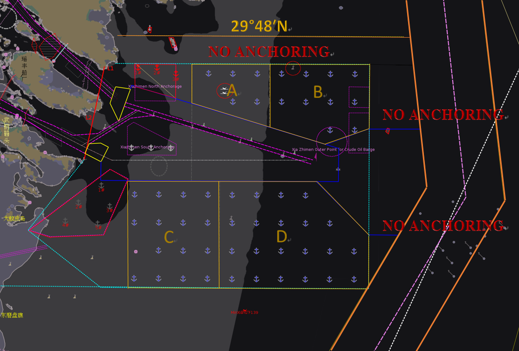
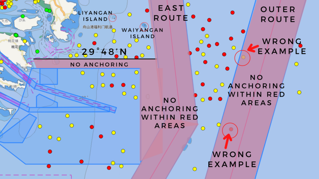

Figure 2. Anchoring Sectors in VTS Zone NO.1
03 RULES ON ANCHORING REQUEST
1. The AIS equipment should be in good condition, and AIS information should be in correct display.
2. Vessels should stand by on VHF channel 08 and 16 at all times.
3. Vessels should report to VTS and request for anchoring position one hour before arriving.
4. The report should include vessel’s name, type, GPS position, maximum draft, berthing or bunkering plans, and any other necessary information.
04 PRINCIPLES OF ANCHORAGE
1. Vessels with inbound plans approved in the Integrated System, and vessels with bunkering plans, can request for anchoring positions in VTS zone NO.1.
2. Vessels without inbound plans or bunkering plans, should anchor in the area East of Longitude 122°43′E or North of Latitude 29°48′N depending on their current ship position.
3. Vessels with bunkering plans in Xiazhimen northern anchorage should anchor in area North of Latitude 29°48′N, if they arrive early.
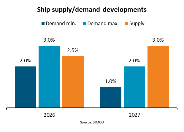
4. Anchoring and drifting are prohibited in areas between the north limit of VTS zone NO.1 Area and Latitude 29°48′N, areas between the east limit of VTS zone NO.1 and the west limit of East Route, and areas 2 nautical miles extended from East Route and 3 nautical miles extended from Outer Route, as shown in red in Figure 3.

Figure 3. Anchoring Prohibited Areas
05 EXITING ANCHORAGE
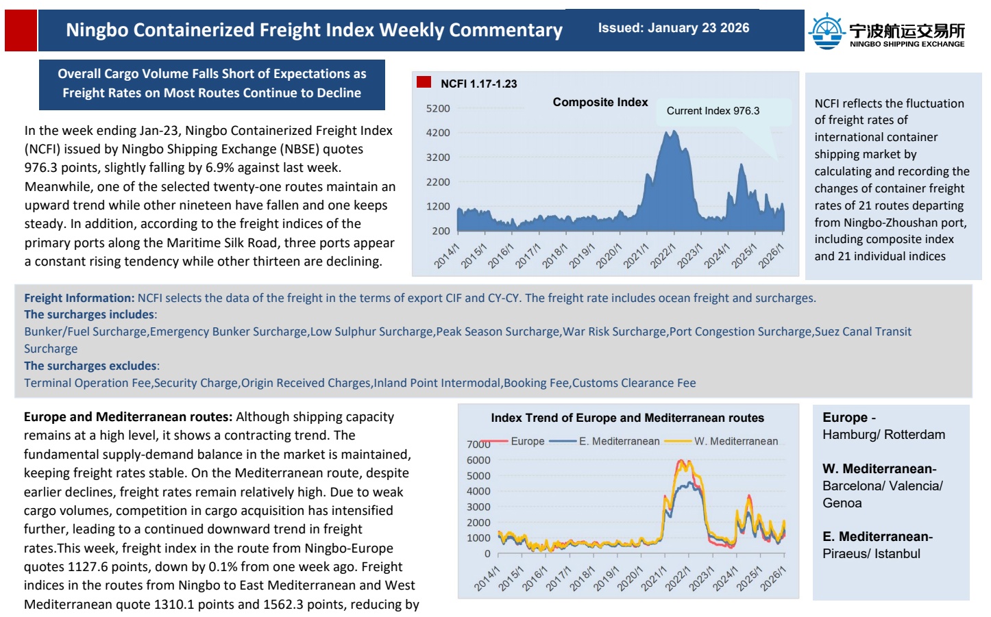
1. Vessels anchored within VTS zone NO.1 and are to proceed inbound should report to VTS in 30 minutes advance before heaving up anchor.
2. To proceed to Xiazhimen channel(Reporting Line 1), vessels exiting sector A and B should join the queue and navigate from North of Deep Water Channel, and vessels leaving sector D should bypass from East of Xiazhimen light vessel before joining the queue.
3. To proceed to Tiaozhoumen channel(Reporting Line 2), vessels exiting sector C and D should join the queue and navigate from North of the recommended route outside of Tiaozhoumen.
4. To proceed to or to exit Xiazhimen northern anchorage, vessels should navigate within the passage between the north limit of the north limit of VTS zone NO.1 and Latitude 29°48′N. Vessels anchored in sector C are allowed to directly proceed to Tiaozhoumen anchorage.


Figure 4. Recommended Approaches Exiting Anchorage


