根据JWC2021年4月26日发布的最新通函JWLA-026,联合战争委员会最近审查了战争、海盗行为、恐怖主义和相关风险 的列明地区,并同意了以下变化:

修改前的区域范围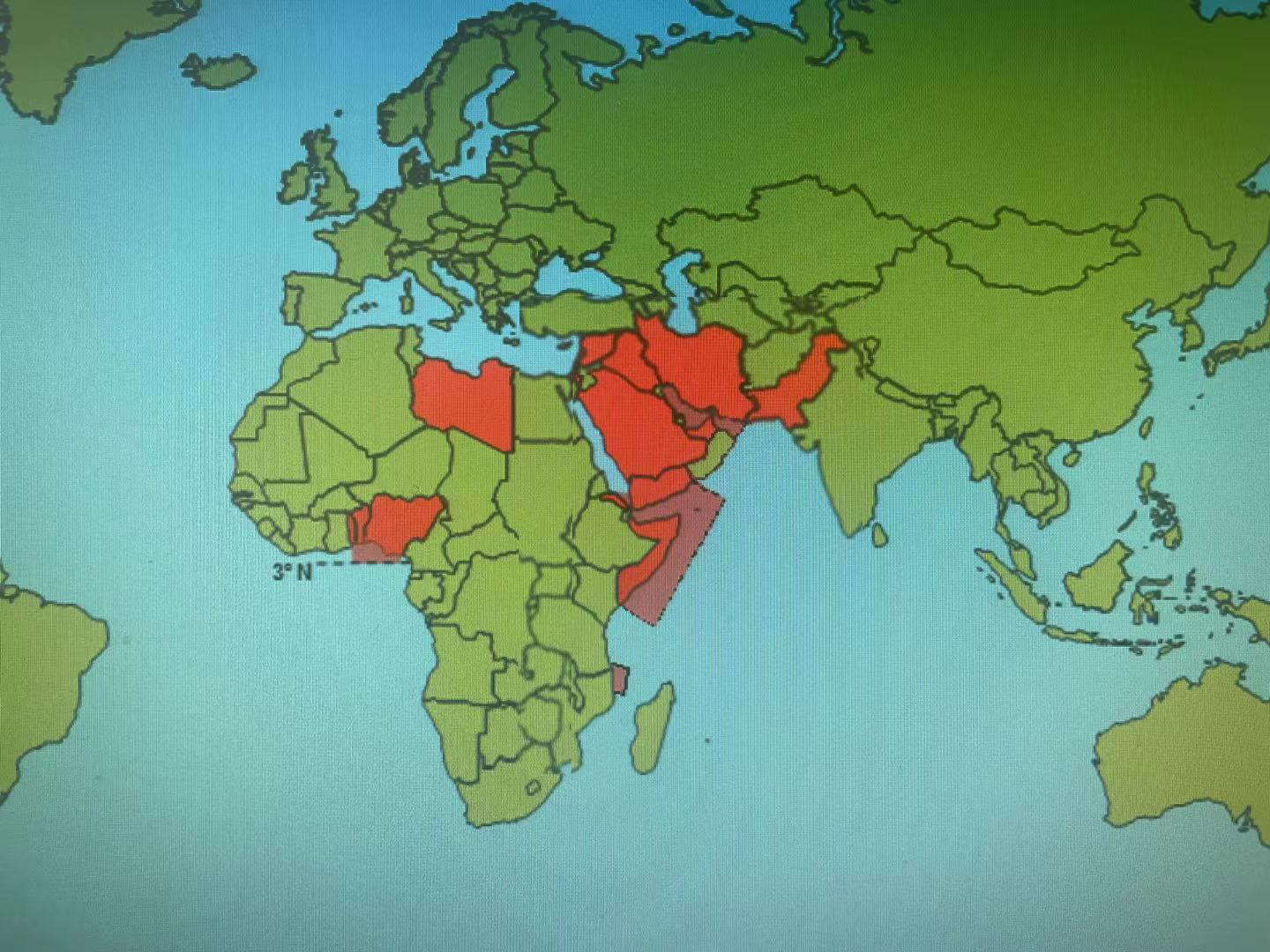
修改后的区域范围
1. 修改了原来的印度洋、亚丁湾和红海南部海盗区:
新的区域是以下边界所包围的水域。
a) 西北方向,北纬15度以南的红海边
b) 东北方向,从北纬16°38.5',东经53°6.5'的也门边境到北纬14°55',东经53°50'的公海点
c) 在东部,从北纬14°55',东经53°50'的公海点到北纬10°48',东经60°15'的公海点,然后到南纬6°45',东经48°45'的公海点一线
d) 西南方向,由南纬1°40',东经41°34'的索马里边境至南纬6°45',东经48°45'的公海点
除非另有规定,毗连领土的沿海水域离岸不超过12海里。
2. 增加了新的德尔加多角(Cabo Delgado)区域
莫桑比克和坦桑尼亚50海里内的水域,由以下边界围成
a) 北边,从南纬10°19.6',东经40°18.9'的Mnazi湾到南纬9°50.7',东经41°7.6'的公海点。
b) 向南,从南纬13°30',东经40°31.6'的Baía do Lúrio到南纬13°30',东经41°02'的公海点。
3. 波斯或阿拉伯湾
波斯或阿拉伯湾及邻近水域,包括阿曼湾和从阿曼在北纬22°42.5'、东经59°54.5'的al-Ḥadd角外的领海界限向东北至北纬25°10.5'、东经61°37.5'的伊朗-巴基斯坦边界线以西的水域
除非另有规定,毗连领土的沿海水域离岸12海里以内除外。
原文:
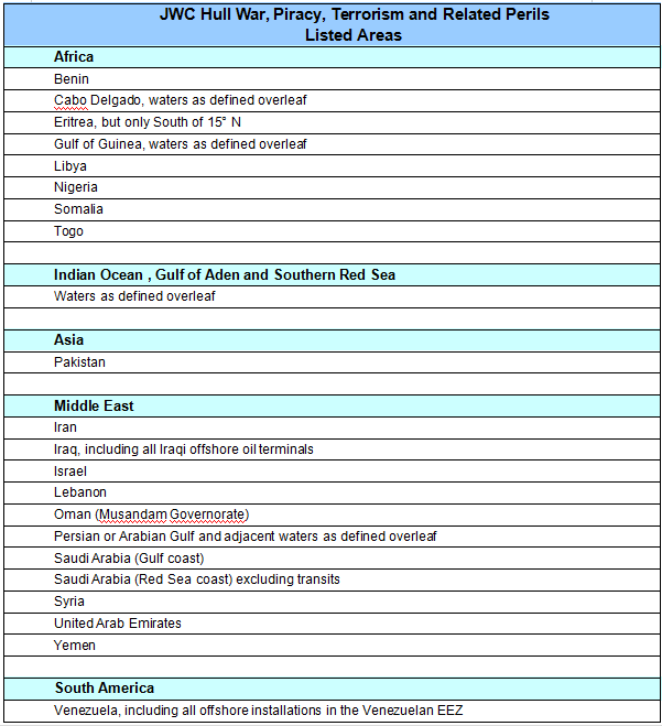
Hull War, Piracy, Terrorism and Related Perils
Listed Areas
The Joint War Committee has recently reviewed the Listed Areas, and has agreed the following changes which are incorporated in the new list as attached.
Added:
Cabo Delgado
The waters within 50 nautical miles of Mozambique and Tanzania enclosed by the following boundaries:
a)To the north, from Mnazi Bay at 10°19.6'S, 40°18.9'E to high seas point at 9°50.7'S, 41°7.6'E.
b)To the south, from Baía do Lúrio at 13°30’S, 40°31.6’E to high seas point 13°30’S, 41°02’E.
Amended:
Indian Ocean, Gulf of Aden and Southern Red Sea
The waters enclosed by the following boundaries:
a) On the north-west, by the Red Sea, south of Latitude 15° N
b) on the northeast, from the Yemen border at 16°38.5’N, 53°6.5’E to high seas point 14°55’N, 53°50’E
c) on the east, by a line from high seas point 14°55’N, 53°50’E to high seas point 10°48’N, 60°15’E, thence to high seas point 6°45’S, 48°45’E
d) and on the southwest, by the Somalia border at 1°40’S, 41°34’E, to high seas point 6°45’S, 48°45’E
excepting coastal waters of adjoining territories up to 12 nautical miles offshore unless otherwise provided.
Persian or Arabian Gulf
Persian or Arabian Gulf and adjacent waters including the Gulf of Oman and waters west of the line from Oman’s territorial limit off Cape al-Ḥadd at 22°42.5'N, 59°54.5'E northeast to the Iran-Pakistan border at 25°10.5'N, 61°37.5'E
excepting coastal waters of adjoining territories up to 12 nautical miles offshore unless otherwise provided.
Oman
Musandam Governorate
The application of this list on individual contracts will be a matter for specific negotiation.
This list will be published on the LMA and IUA websites and will be accessible to all on www.lmalloyds.com and www.iua.co.uk.
Neil Roberts
Secretary
Defined Waters
Cabo Delgado
The waters within 50 nautical miles of Mozambique and Tanzania enclosed by the following boundaries:
a)To the north, from Mnazi Bay at 10°19.6'S, 40°18.9'E to high seas point at 9°50.7'S, 41°7.6'E.
b)To the south, from Baía do Lúrio at 13°30’S, 40°31.6’E to high seas point 13°30’S, 41°02’E.
Gulf of Guinea
The waters enclosed by the following boundaries:
a)On the west, from the coast of Togo 6° 06′ 45″ N, 1°12′E, south to
b)high seas point 0° 40′ S, 3° 00′ E
c)and then east to Cape Lopez Peninsula, Gabon 0°40′S, 8° 42′E.
Indian Ocean, Gulf of Aden and Southern Red Sea
The waters enclosed by the following boundaries:
a) On the northwest, by the Red Sea, south of Latitude 15° N
b) on the northeast, from the Yemen border at 16°38.5’N, 53°6.5’E to high seas point 14°55’N, 53°50’E
c) on the east, by a line from high seas point 14°55’N, 53°50’E to high seas point 10°48’N, 60°15’E, thence to high seas point 6°45’S, 48°45’E
d) and on the southwest, by the Somalia border at 1°40’S, 41°34’E, to high seas point 6°45’S, 48°45’E
excepting coastal waters of adjoining territories up to 12 nautical miles offshore unless otherwise provided.
Persian or Arabian Gulf
Persian or Arabian Gulf and adjacent waters including the Gulf of Oman and waters west of the line from Oman’s territorial limit off Cape al-Ḥadd at 22°42.5'N, 59°54.5'E northeast to the Iran-Pakistan border at 25°10.5'N, 61°37.5'E
excepting coastal waters of adjoining territories up to 12 nautical miles offshore unless otherwise provided.
Definitions:
Named Countries shall include their coastal waters up to 12 nautical miles offshore, unless specifically varied above.
Named Ports shall include all facilities/terminals within areas controlled by the relevant port authority/ies (or as may be more precisely defined by Insurers) including offshore terminals/facilities, and all waters within 12 nautical miles of such but not exceeding 12 nautical miles offshore unless specifically stated.