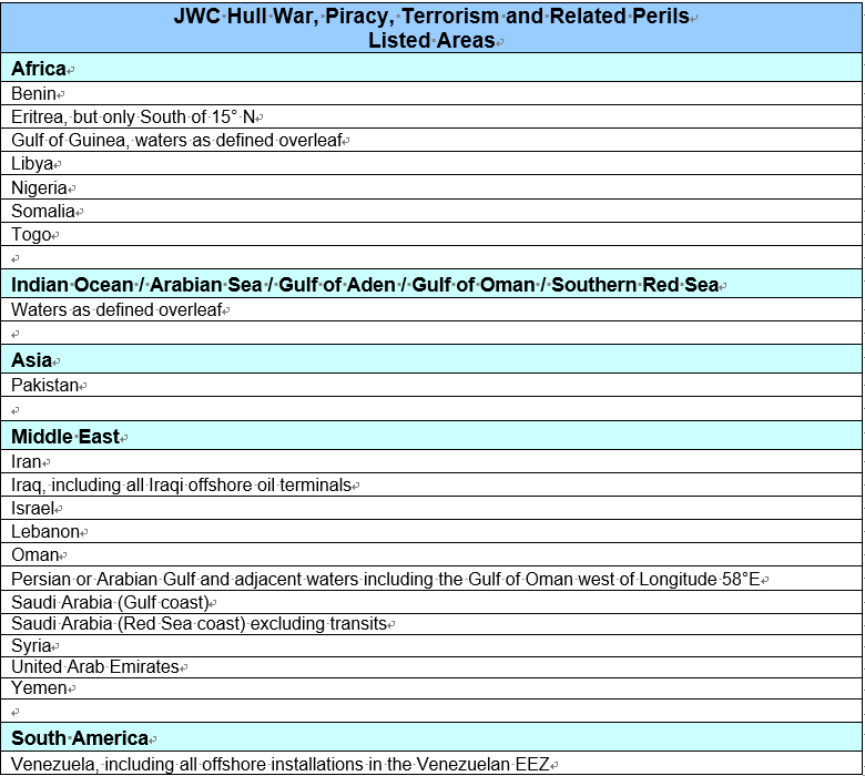
伦敦战争险委员会于2020年9月21日更新了船舶战争险除外区域(最新清单版本为JWLA-025),几内亚湾以下区域被增加在最新除外名单中:
Gulf of Guinea
The waters enclosed by the following boundaries:
a) On the west, from the coast of Togo 6° 06′ 45″N, 1°12′E, south to
b) high seas point 0° 40′ S, 3° 00′ E
c) and then east to Cape Lopez Peninsula, Gabon 0°40′S, 8° 42′E.
详细内容请参阅下附JWC最新通函及更新后的除外区域名单。
友情提示,如果船舶要驶入清单中的战争险除外区域,请务必在船舶投保了普战险的基础上加保特战险,并至少提前48小时通知保险人或保险经纪人。
如果您有此类保险需求,可随时与我司联系。
电话:0532-82971085
邮箱:marine@tnzconsult.com。
原文附后

Hull War, Piracy, Terrorism and Related Perils
Listed Areas
The Joint War Committee has recently reviewed the Listed Areas, and has agreed the following changes which are incorporated in the new list as attached.
Amended:
Gulf of Guinea
The waters enclosed by the following boundaries:
a) On the west,from the coast of Togo 6° 06′ 45″ N, 1°12′E, south to
b) high seaspoint 0° 40′ S, 3° 00′ E
C) and then eastto Cape Lopez Peninsula, Gabon 0°40′S, 8° 42′E.
The application of this list on individual contracts will be a matter for specific negotiation.
This list will be published on the LMA and IUA websites and will be accessible to all on www.lmalloyds.com and www.iua.co.uk.
Neil Roberts
Secretary
Definitions:
Named Countries shall include their coastal waters up to 12 nautical miles offshore,unless specifically varied above.
Named Ports shall include all facilities/terminals within areas controlled by the relevant port authority/ies (or as may be more precisely defined by Insurers) including offshore terminals/facilities, and all waters within 12 nautical miles of such but not exceeding 12 nautical miles offshore unless specifically stated.
Gulfof Guinea
The waters enclosed by the following boundaries:
a) On the west,from the coast of Togo 6° 06′ 45″ N, 1°12′E, south to
b) high seaspoint 0° 40′ S, 3° 00′ E
c) and then eastto Cape Lopez Peninsula, Gabon 0°40′S, 8° 42′E.
Indian Ocean / Arabian Sea / Gulf of Aden / Gulf of Oman / Southern Red Sea
The waters enclosed by the following boundaries:
a) On the north-west, by the Red Sea, south of Latitude 15° N
b) on the west of the Gulf ofOman by Longitude 58° E
c) on the east, Longitude 65° E
d) and on the south, Latitude 12°S
excepting coastal waters of adjoining territories up to 12 nautical miles offshore unless otherwise provided.