The following areas are prescribed compulsory coastal pilotage areas under MO54:
The Hydrographers Passage pilotage area means the area bounded by a line that progressively joins the following points:
Inner Route pilotage area means the waters bounded by:
a. the Australian mainland
b. the outer eastern edge of the Great Barrier Reef
c. the northern boundary of the Great Barrier Reef Region (latitude 10º 41.00′S)3
d. latitude 16º 39.91′S
e. the Torres Strait, excluding the waters to the north of latitude 10º 28.00′S and east of longitude 142º 39.00′E.
* Great Barrier Reef Region has the meaning given by section 3 of the Great Barrier Reef Marine Park Act 1975.
Torres Strait means the waters bounded:
a. on the south by latitude 10º 41.00’S
b. on the east:
i. for a ship moving eastward - by longitude 143º 22.00’E
ii. for any other vessel - by longitude 143º 24.00’E
c. on the north by the line of Australia’s Exclusive Economic Zone (EEZ)
d. on the west:
i. for a vessel of less than 8m draught - by longitude 142º 05.00’E
ii. for a vessel of 8m draught or more moving eastward - by longitude 141º 50.00’E
iii. for a vessel of 8m draught or more moving westward - by longitude 141º 51.70’E.
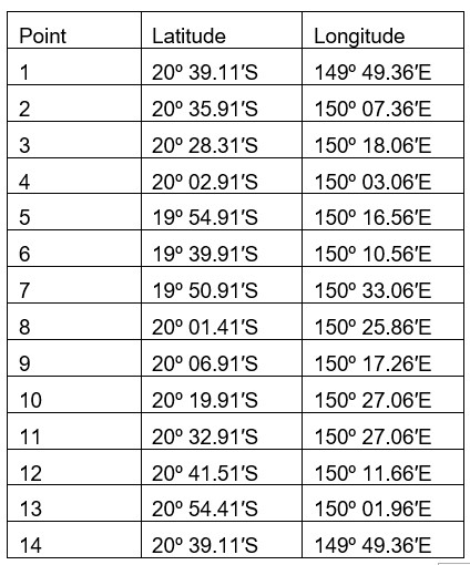
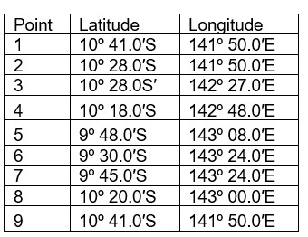
Great North East Channel pilotage area means the area bounded by a line that progressively joins the following points:
The Whitsundays pilotage area means the area bounded by a line that begins at the northernmost point of Cape Gloucester at low water, at about latitude 20º 03.94′S, longitude 148º 27.51′E, and continues progressively:
a. to the following points:
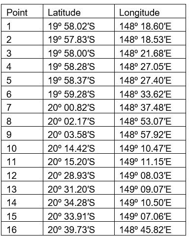
b. west along parallel of latitude 20º 39.73′S to the coastline of the mainland at low water, near Midge Point
c. generally northerly, easterly, south-easterly and north-westerly along the coastline of the mainland at low water to the point where the boundary began.
Masters or vessel owners may apply to AMSA for an exemption from the pilotage requirements of the Navigation Act. An exemption application must also be made to the Great Barrier Marine Park Authority (GBRMPA) to navigate without a licensed pilot in the Hydrographers Passage, Inner Route and Whitsundays pilotage areas.
The opinions expressed herein are the author's and not necessarily those of The Xinde Marine News.
Please Contact Us at:
media@xindemarine.com


.gif)


 Ningbo Containerized Freight Index Weekly Commentar
  Ningbo Containerized Freight Index Weekly Commentar
  BIMCO Shipping Number of the Week: Bulker newbuildi
  Ningbo Containerized Freight Index Weekly Commentar
  Ningbo Containerized Freight Index Weekly Commentar